


MH370: NEW Evidence Reopens Case 10 Years Later


This year is officially the 10 year anniversary of Malaysian Airlines Flight MH370 going missing. On the 10th anniversary promising new evidence published by Richard Godfrey, et al. has finally reopened the investigation.
First here’s a brief timeline of everything that happened and the evidence collected thus far:
March 7th, 2014:
Flight MH370 departed from Kuala Lumpur International Airport at 12:41 am heading to Beijing with 227 passengers and 12 crew on board.
40 minutes later…

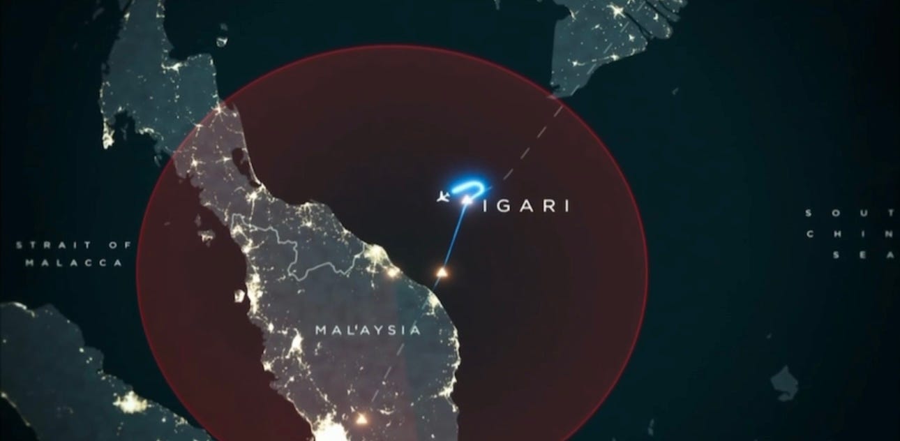
About 40 minutes into the flight, MH370 approached its first checkpoint called IGARI when the plane entered Vietnamese airspace.
Malaysian air traffic control (ATC) sends MH370 a routine message, “Malaysian 370 contact Ho Chi Minh one two zero decimal niner, good night.”
One of the two captains aboard MH370 replied back, “Good night” at 17:19:30 UTC. That is the last time we ever hear from anyone on board flight MH370.
The Vanishing
66 seconds later, the transponder symbol for MH370 vanishes off the radar display. Malaysian Airlines Flight MH370 had officially and suddenly gone “dark”.
17 minutes will pass before the Vietnamese ATC realize that MH370 is not showing up on their radars anymore. What happened in those 17 minutes is still haunting us to this day.
But, before the flight disappeared, it’s last movements appeared to divert back over Malaysia towards the Malacca Strait per military radar data.
The race to find the plane began immediately, but how do you track a ghost plane?
The First Clue
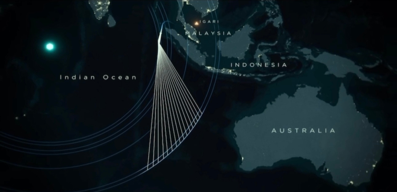
Interestingly enough, the first clue didn’t come from the aviation industry, but from a satellite company in London called Inmarsat. One of it’s satellites stationed above the Indian Ocean was receiving automatic signals every hour on the hour from MH370.
This was the first piece of evidence that the plane didn’t simply vanish into thin air. It was somewhere out there airborne, still transmitting a signal.
The question was, where? Unfortunately, the satellite data works like a handshake. The satellite reaches its hand out and MH370 reaches out to shake back. It can tell us the plane exists in airspace, but it can’t tell us where it is or where it’s going.
But, what the satellite data did tell us was that the signal went on for the next 7 hours - meaning MH370 was in the air for 7 hours after its last official contact.
Which, if you recall, is 1.5 hours longer than the original flight destination
The Second Clue
The next clue came from a joint effort between Inmarsat, the London satellite company and from Boeing’s flight data.
From this the MH370 search team figured out that MH370 was airborne for 7 hours and 46 minutes. It officially ran out of fuel after 7 hours and 35 min, then most likely crashed 11 min later.
From here, possible routes were calculated based on the flight duration and amount of fuel onboard to eventually map out 7 arcs, or regions where MH370 pinged on their satellite.
And across all the data outcomes, each one led to the 7th and final arc as the crash site, located in the South Indian Ocean, 2000 miles from the original search area.
The 2014 Search
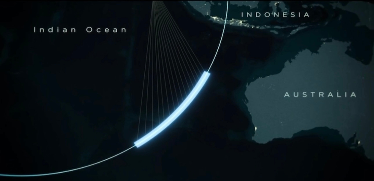
Now, with a more concrete region of interest, a multi-country search ensued 9 days after the flight disappeared, searching in a 112 mile radius around the 7th arc.
Hydrophones were deployed to detect pings from the aircraft’s black box. The black box will ping periodically for 30 days, so it was a race against the clock to pick up any signals in the ocean.
The deep sea team, Ocean Infinity, went through that 7th arc area with a fine tooth comb and found - nothing. No pings, just nothing.
The ocean was silent and so was MH370.
Debris Discovered
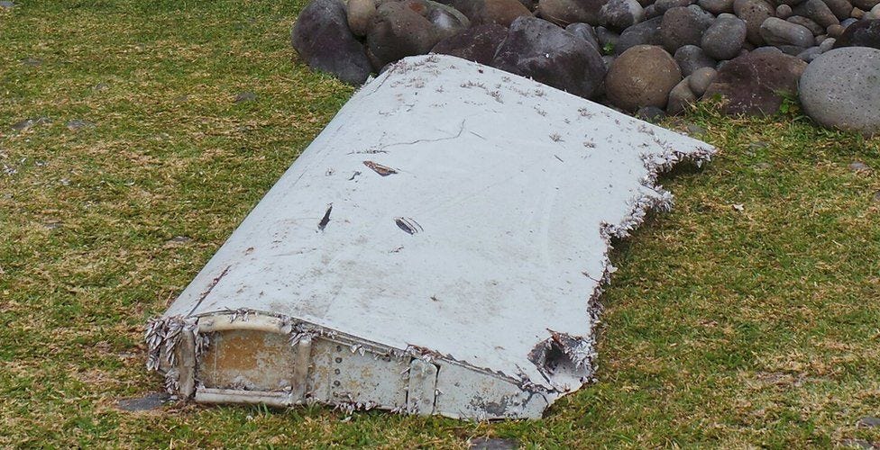
508 days would pass after March 7th, 2014 before another clue emerged. The first piece of debris from MH370 was found. It washed ashore covered in barnacles on Reunion Island just off the coast of Madagascar, 2000 miles west of the 7th arc search area.
The debris was identified as a flaperon (the piece that moves up and down to create drag) from the right wing of MH370.
This find was incredibly exciting, so the MH370 search team reverse engineered the drift path of this flaperon using simulations and a real Boeing 777 flaperon in the ocean. Through this they were able to confirm that the point of origin of the flaperon, before it drifted, was smack dab on the 7th arc. This was the first dual confirmation that the 7th arc is where MH370 is located.
Unfortunately, after 3.5 years of searching with no joy, the underwater search was officially called off by the Australian, Malaysian and Chinese governments. The team stated they would only renew the search if significant new information comes to light.
Civilian Sleuths Crack the Case?
Jean-Luc Marchard, a leading ATC manager and aerospace expert, along with French pilot, Patrick belly, have worked for the last 2 years analyzing old and new data to help solve the mystery of MH370.
With Blelly’s pilot background they were able to get access to a Boeing 777 simulator to retrace the final flight of MH370. From this there were able to answer a question that has been gnawing at everyone for years. Why did the pilots not check in at IGARI and why did the plane disappear off the radar?
Well, each commercial airplane, including MH370, are fitted with transponders. The transponder relays the airplane’s position to ATC, so Blelly and Marchard knew that the only way for a plane to go dark as MH370 did, was to switch off the transponder.
The transponder is a physical switch and from an analysis of Malaysian ATC data, it was found that the transponders were manually switched off from the cockpit.
Why anyone would need to do that is the question the duo is trying to answer.
But, what Jean-Luc Marchard does know is that whoever decided to switch off the transponder in the IGARI region was very clever…because this stretch of open ocean between KL and Vietnam, “is a bit of a black hole” says Marchard.
“If you want to disappear, this is where you do it.”
That was all the known evidence about MH370 and that appeared to be it, until quite literally a few months ago…
NEW Evidence

Now we’ve finally come to the new evidence.
The man of the hour is Richard Godfrey, a retired aerospace engineer, who has become one of the most impactful civilian sleuths on the MH370 case thus far.
He told me he has worked on the MH370 case voluntarily every single day, for 8 hours a day, for the last 10 years.
Thanks to him, we finally have extremely promising new info about the location of MH370 on the 10th anniversary of the plane’s disappearance, no less!
My first question to him was,
“What were you able to find that three governments, state of the art resources and millions of dollars couldn’t find?”
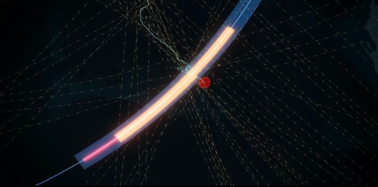
Godfrey built off the evidence from the original 2014 investigation, but he brought to the table a new tool that proved to be a total game changer. That tool is called WSPR, or weak signal propagation reporter.
WSPR tests the strengths of radio waves across the globe. Every two minutes, radio signals around the world transmit a weak radio signal that can travel across great distances including over open ocean.
As a result, WSPR can also be used to detect and track aircrafts. Anytime a major object, like a plane, passes through any of these radio paths, it causes a disturbance and that disturbance is recorded on WSPR.
All the data collected in the original search that led to the 7 arcs, only gave a radius of where the plane pinged in the air. It could never give an exact location of the plane at a certain time point.
This is precisely why the WSPR data is so exciting because WSPR is synchronized with GPS time. So, we know precisely when the signal was sent and from where.
This WSPR database goes back to 2008 and contains billions of rows of data. On top of that, roughly 5 million rows of data are added every single day - so this is not only a massive data set, but a massive undertaking as well.
Godfrey narrowed down the WSPR data by analyzing all WSPR signals on the night of March 8, 2014, looking for any anomalies in the signal frequency.
His persistence paid off, because Godfrey caught 2 anomalies in the Southern Indian Ocean on the night MH370 went missing.
Soon those 2 disturbances grew to 130 disturbances that mapped out the flight path of MH370 and the disturbances end, just past the 7th arc in an area that has never been searched before.
This was a Eureka! moment and provided the new evidence that the MH370 search team needed to reopen the case.
But there are still several questions, like how is it possible for the plane to still be flying past the 7th arc when it was calculated to be out of fuel by then? All these questions and more are answered by Richard Godfrey himself below.
The content beyond this point is for paid subscribers. Please consider becoming a paid subscriber of Today I Learned Science to show your appreciation and support her work. It is this paid support that allows for more high quality content, interviews and more. Thank you to all subscribers for your support and contribution!!
Keep reading with a 7-day free trial
Subscribe to Today I Learned Science to keep reading this post and get 7 days of free access to the full post archives.